No-regret adaptation plans and stakeholder interaction
This service will be tailored to the actual needs and will allow to design no-regret adaption plans that deliver the intended impact to improve the health of the local inhabitants.
CHARISMA plans regular interactions with stakeholders to define the service and include relevant information with links to health-data.
An example of such information is a mapping of heat stress levels and the number of related hospitalizations. Such a relation needs not to be proportional; especially poorer citizens do not always have the financial means to protect themselves from heat stress whereas more economic capability allows the installment of e.g. air conditioning. In poorer regions of a city, with high levels of heat stress and few hospitals one can therefore expect hospitalizations to worsen due to climate change, necessitating adequate urban planning.
No-regret adaptation planning implies that actions put in place now remain effective in the decades to come.
Reliable and scientifically underpinned
The information on which adaptation plans are based must therefore be reliable and scientifically underpinned. For this reason indicators pertaining future heat stress will be based on a combination of quality-assured climate data from the Copernicus Climate Data Store (CDS) and local terrain data. This data will service as input into VITO’s in-house developed model UrbClim, which accumulates the more than 20 years of experience in monitoring, modelling and forecasting of VITO’s Climate Team.
Urbclim
UrbClim produces validated urban climate predictions up to 2100, at speeds up to 100 times quicker than regular models. Urban climate data provided by UrbClim typically consists of air temperatures, humidity and wind speeds, as well as heat stress indicators such as number of heat-wave days and human comfort indices. Especially the latter is of great significance as satellite data typically only covers surface temperatures, which stand-alone are not representative of human comfort.
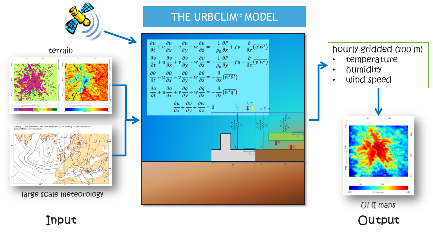
Using remote sensing based land data allows VITO’s urban heat island/heat stress assessment service to be applied for any city in the world, simulating long time periods at a spatial resolution of 100m x 100m without the need of local data.
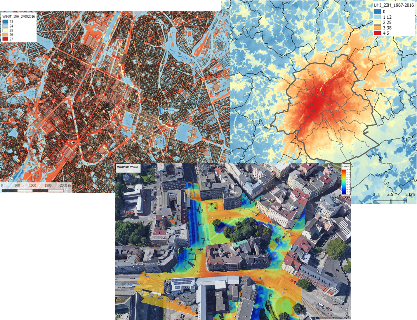
While UrbClim outputs hourly gridded data at 100m resolution, in collaboration with urban planners, the service can be tailored to produce data at street level and include future land use. High-resolution mapping for example yields thermal comfort maps at 1m resolution.
Urban expansion
Urban Climate Services provide heat-island and heat stress modelling/forecasting at user-defined scales without compromising accuracy.
With urban areas growing exponentially in India, it is imperative that urban expansion is taken into account when considering the Urban Heat Island effects.
For this purpose VITO’s GeoDynamiX toolbox is employed. This toolbox enables the modelling of future land use, thereby also including urban growth and population estimates up to 2100.
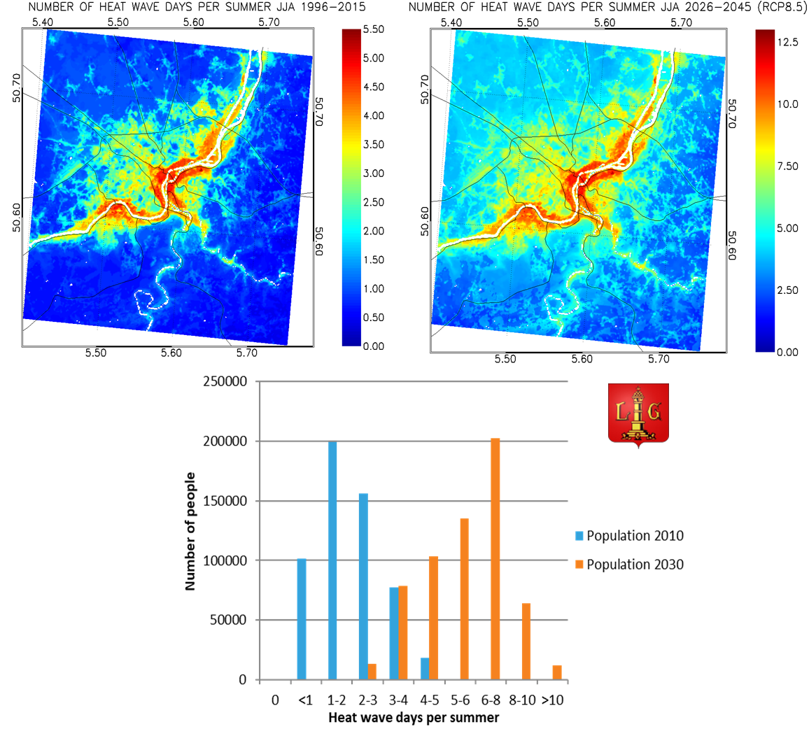
The Urban Climate Services combine urban expansion, population growth and climate change projections to assess the impact of climate change (e.g. number of heat wave days) up to 2100. The above figures show (clockwise) the present number of heat wave days in the city of Liege, the number of predicted heat wave days (taking into account climate change and urban growth) in the period 2026-2045 and the population exposed to a number of heat wave days.
Insights for the implementation of adaptation and mitigation strategies
Combining both tools, VITO’s urban climate service enables the assessment and visualization of local-scale climate-change impact. Such data gives sector-specific experts the necessary insight to design and implement no-regret adaptation and mitigation strategies whereby local heat-reducing adaptation measures (e.g. blue-green infrastructure, reduced soil sealing, green/white roofs, …) can be assessed in terms of their efficacity to improve urban thermal comfort for the next decades.